- Home
- Tutorial
- Resource Guides
- Focus Areas
- LSF Programs
-
Professional
Development - Review Process
-
A project of LSF
Search for Resources
Description
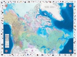
The Indigenous Peoples Atlas of Canada tiled map offers a unique perspective on our country’s geography that is vital to understanding the history and diverse cultures of the Indigenous Peoples of Canada. The giant floor map does not contain provincial boundaries, names of provinces, or many of the current names of cities and towns. It shows unsettled land claims, treaties and settlement lands, reserves and locations of former residential schools in Canada.
The map is intended to be walked on and is accompanied by a binder of educational resources and activities designed for elementary and secondary students. This fun and interactive experience allows students to explore multiple aspects connected to history and present-day Indigenous Peoples living in Canada. The map is large enough to cover the gymnasium floor and has numerous layers of information that highlight the complexity of Indigenous histories and the diversity of cultures among Métis, Inuit and First Nations peoples living in Canada.
Teachers can request the map for two weeks or download the map in a smaller size as a tiled map. The IPAC teacher’s guide contains learning activities and ways to take action on these topics:
- Climate Change
- Connection to The Land/Demographics
- Indigenous Governance
- Housing
- Human Rights
- Indigenous Languages
- Movement of People
- Notable People
- Original Place Names
- Residential Schools
- Seasonal Cycles and Migration
- Symbols
- Using the Timeline
- Trade Routes and Traplines
- Treaties, Land Disputes, Agreements and Rights
General Assessment
Recommendation of how and where to use it
This resource is intended to be used as a learning tool to help educators begin a conversation with students about Indigenous Peoples knowledge and cultures while expanding their own knowledge. The map can be used by teachers across the country in conjunction with lessons and subject matter ranging from climate change and human rights to Indigenous languages and the history of residential schools.
The RCGS recommends that you use this resource as a starting point and reach out to Indigenous communities, organizations, and groups in your area to learn more about reconciliation.
Relevant Curriculum Units
The following tool will allow you to explore the relevant curriculum matches for this resource. To start, select a province listed below.
- Step 1Select a province
- Alberta
- Step 2Select a grade level
- Kindergarten
- Step 3Select a subject
- Social Studies
- Step 4Relevant matches
- Time and Place: Exploring the dynamic relationships between people, place, and time supports understanding of perspectives and events to make meaning of the world
- Grade 1
- Step 3Select a subject
- Social Studies
- Step 4Relevant matches
- Citizenship: Understanding local, national, and global issues empowers individual and collective action toward an inclusive society
- Time and Place: Exploring the dynamic relationships between people, place, and time supports understanding of perspectives and events to make meaning of the world
- Grade 2
- Step 3Select a subject
- Social Studies
- Step 4Relevant matches
- Time and Place: Exploring the dynamic relationships between people, place, and time supports understanding of perspectives and events to make meaning of the worl
- Grade 4
- Step 3Select a subject
- Social Studies
- Step 4Relevant matches
- Citizenship: Understanding local, national, and global issues empowers individual and collective action toward an inclusive society
- Grade 7
- Step 3Select a subject
- Social Studies
- Step 4Relevant matches
- Canada: Origins, Histories and Movement of Peoples: Following Confederation: Canadian Expansions
- Grade 10
- Step 3Select a subject
- Social Studies
- Step 4Relevant matches
- Social Studies 10-1(Perspectives on Globalization) Legacy of Historical Globalization
- British Columbia
- Step 2Select a grade level
- Kindergarten
- Step 3Select a subject
- Social Studies
- Step 4Relevant matches
- Our communities are diverse and made of individuals who have a lot in common
- Identity and Families
- Grade 1
- Step 3Select a subject
- Social Studies
- Step 4Relevant matches
- Local Communities: Healthy communities recognize and respect the diversity of individuals and care for the local environment
- Grade 2
- Step 3Select a subject
- Social Studies
- Step 4Relevant matches
- Regional and Global Communities: Canada is made up of many diverse regions and communities
- Grade 3
- Step 3Select a subject
- Social Studies
- Step 4Relevant matches
- Global Indigenous Peoples: Learning about indigenous peoples nurtures multicultural awareness and respect for diversity.
- Global Indigenous Peoples: Indigenous knowledge is passed down through oral history, traditions, and collective memory.
- Global Indigenous Peoples:Indigenous societies throughout the world value the well-being of the self, the land, spirits, and ancestors
- Grade 4
- Step 3Select a subject
- Social Studies
- Step 4Relevant matches
- First peoples and European Contact: Demographic changes in North America created shifts in economic and political power.
- First peoples and European Contact: Interactions between First Peoples and Europeans lead to conflict and cooperation, which continues to shape Canada’s identity
- Grade 5
- Step 3Select a subject
- Social Studies
- Step 4Relevant matches
- Canadian Issues and Governance: Canada’s policies and treatment of minority peoples have negative and positive legacies
- Grade 6
- Step 3Select a subject
- Social Studies
- Step 4Relevant matches
- Global Issues and Governance: Complex global problems require international cooperation to make difficult choices for the future.
- Grade 7
- Step 3Select a subject
- Social Studies
- Step 4Relevant matches
- The Ancient World to the 7th Century: Increasingly complex societies required new systems of laws and government.
- Grade 10
- Step 3Select a subject
- English/Language Arts
- Step 4Relevant matches
- English First Peoples - Literary Studies: First Peoples texts play a role within the process of Reconciliation.
- English First Peoples-Spoken language: First Peoples oral text plays a role within the process of Reconciliation
- English First Peoples-Writing: First Peoples texts play a role within the process of Reconciliation
- Social Studies
- Step 4Relevant matches
- Social Studies 10 -Canada and the World: 1914 to the Present: Historical and contemporary injustices challenge the narrative and identity of Canada as an inclusive, multicultural society
- Grade 11
- Step 3Select a subject
- English/Language Arts
- Step 4Relevant matches
- English First Peoples - Literary Studies + New Media: First Peoples literature plays a role within the process of Reconciliation
- English First Peoples - Literary Studies + Writing: First Peoples literature plays a role within the process of Reconciliation
- Social Studies
- Step 4Relevant matches
- Explorations in Social Studies 11(Human Geography, Contemporary Indigenous Studies, Social Justice) : Indigenous peoples are reclaiming mental, emotional, physical, and spiritual well-being despite the continuing effects of colonialism
- Grade 12
- Step 3Select a subject
- English/Language Arts
- Step 4Relevant matches
- English First Peoples - Literary Studies + Writing: First Peoples literature plays a role within the process of Reconciliation
- English First Persons 12: First Peoples voices and texts play a role within the process of Reconciliation.
- English Studies 12 The examination of First Peoples cultures and lived experiences through text builds understanding of Canadians’ responsibilities in relation to Reconciliation.
- Social Studies
- Step 4Relevant matches
- B.C. First Peoples: Cultural expressions convey the richness, diversity, and resiliency of B.C. First Peoples.
- B.C. First Peoples: The identities, worldviews, and languages of B.C. First Peoples are renewed, sustained, and transformed through their connection to the land
- B.C. First Peoples: The impact of contact and colonialism continues to affect the political, social, and economic lives of B.C. First Peoples
- B.C. First Peoples: Through self-governance, leadership, and self-determination, B.C. First Peoples challenge and resist Canada's ongoing colonialism
- Contemporary Indigenous Studies: Indigenous peoples are reclaiming mental, emotional, physical, and spiritual well-being despite the continuing effects of colonialism
- Contemporary Indigenous Studies: Indigenous peoples continue to advocate and assert rights to self-determination
- Contemporary Indigenous Studies: Reconciliation requires all colonial societies to work together to foster healing and address injustices
- Contemporary Indigenous Studies: The identities, worldviews, and languages of indigenous peoples are renewed, sustained, and transformed through their connection to the land.
- Physical Geography 12: Interactions between human activities and the atmosphere affect local and global weather and climate
- Social Justice: Individual worldviews shape and inform our understanding of social justice issues.
- Manitoba
- Step 2Select a grade level
- Kindergarten
- Step 3Select a subject
- Social Studies
- Step 4Relevant matches
- Being Together:: The People around Me
- Grade 1
- Step 3Select a subject
- Social Studies
- Step 4Relevant matches
- My Environment
- Grade 2
- Step 3Select a subject
- Social Studies
- Step 4Relevant matches
- Communities in Canada: Communities in Canada
- Grade 3
- Step 3Select a subject
- Social Studies
- Step 4Relevant matches
- Communities of the World: Communities of the World
- Grade 4
- Step 3Select a subject
- Social Studies
- Step 4Relevant matches
- Manitoba, Canada & the North: Places & Stories - History of Manitoba
- Manitoba, Canada & the North: Places and Stories -Geography of Canada
- Grade 5
- Step 3Select a subject
- Social Studies
- Step 4Relevant matches
- Peoples and Stories of Canada to 1867: Early European Colonization (1600 to 1763)
- Peoples and Stories of Canada to 1867: First Peoples
- Grade 6
- Step 3Select a subject
- Social Studies
- Step 4Relevant matches
- Canada - A Country of Change (1867 to Present): An Emerging Nation (1914-1945)
- Grade 7
- Step 3Select a subject
- Social Studies
- Step 4Relevant matches
- People & Places in the World: Human Impact in Europe or the Americas
- People & Places in the World: World Geography
- Grade 9
- Step 3Select a subject
- Social Studies
- Step 4Relevant matches
- Canada in the Contemporary World:Diversity and Pluralism in Canada
- Grade 12
- Step 3Select a subject
- Social Studies
- Step 4Relevant matches
- Citizenship and Sustainability: Area of Inquiry: Social Justice and Human Rights
- Citizenship and Sustainability:Area of Inquiry: Indigenous Peoples
- Global Issues
- Global Issues
- New Brunswick
- Step 2Select a grade level
- Grade 7
- Step 3Select a subject
- Social Studies
- Step 4Relevant matches
- Cultures
- Empowerment: Civics
- Atlantic Canada and the World:
- Grade 9
- Step 3Select a subject
- Social Studies
- Step 4Relevant matches
- Canadian Identities: Geography
- Grade 10
- Step 3Select a subject
- Social Studies
- Step 4Relevant matches
- Civics 10: Human Rights
- Newfoundland & Labrador
- Step 2Select a grade level
- Kindergarten
- Step 3Select a subject
- Social Studies
- Step 4Relevant matches
- Place
- Grade 1
- Step 3Select a subject
- Social Studies
- Step 4Relevant matches
- Time and Change
- Grade 2
- Step 3Select a subject
- Social Studies
- Step 4Relevant matches
- Individuals and Groups
- Grade 5
- Step 3Select a subject
- Social Studies
- Step 4Relevant matches
- Societies: Exploring the Past
- Grade 6
- Step 3Select a subject
- Social Studies
- Step 4Relevant matches
- How Can We Be Good Global Citizens?
- Grade 7
- Step 3Select a subject
- Social Studies
- Step 4Relevant matches
- Cultural Empowerment
- Grade 8
- Step 3Select a subject
- Social Studies
- Step 4Relevant matches
- History as a Story of the Past in the Present
- Grade 9
- Step 3Select a subject
- Social Studies
- Step 4Relevant matches
- Geographic Influences on Identity: Place and Peopel
- Canadian Identity
- Northwest Territories
- Step 2Select a grade level
- Kindergarten
- Step 3Select a subject
- Social Studies
- Step 4Relevant matches
- Our communities are diverse and made of individuals who have a lot in common
- Identity and Families
- The World and Me
- Grade 1
- Step 3Select a subject
- Social Studies
- Step 4Relevant matches
- Connecting and Belonging: My Environment
- Local Communities: Healthy communities recognize and respect the diversity of individuals and care for the local environment
- Grade 2
- Step 3Select a subject
- Social Studies
- Step 4Relevant matches
- Communities in Canada: Communities in Canada
- Regional and Global Communities: Canada is made up of many diverse regions and communities
- Grade 3
- Step 3Select a subject
- Social Studies
- Step 4Relevant matches
- Communities of the World: Communities of the World
- Communities of the World:Connecting with Canadians
- Global Indigenous Peoples: Learning about indigenous peoples nurtures awareness and respect for diversity.
- Global Indigenous Peoples: Indigenous knowledge is continues to be shared through oral history, traditions, and collective memory.
- Global Indigenous Peoples: Indigenous nations throughout the world value the well-being of the self, the land, spirits, and ancestors
- Grade 4
- Step 3Select a subject
- Social Studies
- Step 4Relevant matches
- First peoples and European Contact: Demographic changes in North America created shifts in economic and political power.
- First peoples and European Contact: Interactions between First Peoples and Europeans lead to conflict and cooperation, which continues to shape Canada’s identity
- Grade 5
- Step 3Select a subject
- Social Studies
- Step 4Relevant matches
- Canadian Issues and Governance: Canada’s policies and treatment of minority peoples have negative and positive legacies
- Grade 6
- Step 3Select a subject
- Social Studies
- Step 4Relevant matches
- Global Issues and Governance: Complex global problems require international cooperation to make difficult choices for the future.
- Grade 7
- Step 3Select a subject
- Social Studies
- Step 4Relevant matches
- The Ancient World to the 7th Century: Increasingly complex societies required new systems of laws and government.
- Grade 9
- Step 3Select a subject
- Social Studies
- Step 4Relevant matches
- 1750 to 1921: Disparities in power alter the balance of relationships between individuals and between societies.
- Grade 10
- Step 3Select a subject
- English/Language Arts
- Step 4Relevant matches
- English First Peoples - Literary Studies: First Peoples texts play a role within the process of Reconciliation.
- English First Peoples-Spoken language: First Peoples oral text plays a role within the process of Reconciliation
- English First Peoples-Writing: First Peoples texts play a role within the process of Reconciliation
- Social Studies
- Step 4Relevant matches
- Module 2: Residential Schools
- Northern Studies
- Northern Studies 10: Module 1: Northern Identity
- Social Studies 10 -Canada and the World: 1914 to the Present: Historical and contemporary injustices challenge the narrative and identity of Canada as an inclusive, multicultural society
- Grade 11
- Step 3Select a subject
- English/Language Arts
- Step 4Relevant matches
- English First Peoples - Literary Studies + New Media: First Peoples literature plays a role within the process of Reconciliation
- English First Peoples - Literary Studies + Writing: First Peoples literature plays a role within the process of Reconciliation
- Social Studies
- Step 4Relevant matches
- Explorations in Social Studies 11: Indigenous peoples are reclaiming mental, emotional, physical, and spiritual well-being despite the continuing effects of colonialism
- Grade 12
- Step 3Select a subject
- English/Language Arts
- Step 4Relevant matches
- English First Peoples - Literary Studies + Writing: First Peoples literature plays a role within the process of Reconciliation
- English First Persons 12: First Peoples voices and texts play a role within the process of Reconciliation.
- English Studies 12 The examination of First Peoples cultures and lived experiences through text builds understanding of Canadians’ responsibilities in relation to Reconciliation.
- Nova Scotia
- Step 2Select a grade level
- Kindergarten
- Step 3Select a subject
- Social Studies
- Step 4Relevant matches
- Primary
- Grade 1
- Step 3Select a subject
- Social Studies
- Step 4Relevant matches
- Social Studies 1: Mi'kmaq Communities
- Grade 2
- Step 3Select a subject
- Social Studies
- Step 4Relevant matches
- Social Studies 2:People
- Grade 3
- Step 3Select a subject
- Social Studies
- Step 4Relevant matches
- Social Studies 3:Heritage
- Grade 4
- Step 3Select a subject
- Social Studies
- Step 4Relevant matches
- Social Studies 4: Canadian Landscape
- Grade 5
- Step 3Select a subject
- Social Studies
- Step 4Relevant matches
- Societies: Introduction
- Social Studies 5
- Grade 6
- Step 3Select a subject
- Social Studies
- Step 4Relevant matches
- Social Studies 6: World Issues
- Grade 7
- Step 3Select a subject
- Social Studies
- Step 4Relevant matches
- Social Studies 7 - Many Cultures: One Shared History: Government Policies and the Mi'kma'ki
- Grade 8
- Step 3Select a subject
- Social Studies
- Step 4Relevant matches
- Social Studies 8 - A Changing Canadian Society: Indigenous Experience
- Nunavut
- Step 2Select a grade level
- Kindergarten
- Step 3Select a subject
- Social Studies
- Step 4Relevant matches
- Being Together: The Land: Place & People
- Grade 1
- Step 3Select a subject
- Social Studies
- Step 4Relevant matches
- Connecting and Belonging: The Land: Place & People
- Grade 2
- Step 3Select a subject
- Social Studies
- Step 4Relevant matches
- Communities in Canada: The Land: Place & People
- Grade 3
- Step 3Select a subject
- Social Studies
- Step 4Relevant matches
- Connecting With the World: The Land: Place & People
- Grade 4
- Step 3Select a subject
- Social Studies
- Step 4Relevant matches
- Provinces and Territories: Our Places, Stories, and Traditions: The Land: Place & People
- Provinces and Territories: Our Places, Stories, and Traditions: Time, Continuity & Change
- Grade 5
- Step 3Select a subject
- Social Studies
- Step 4Relevant matches
- Our Northern Land and Its People: How Our Northern Territory Came to Be
- Grade 6
- Step 3Select a subject
- Social Studies
- Step 4Relevant matches
- Our Place in the Nation: The Faces
- Grade 9
- Step 3Select a subject
- Social Studies
- Step 4Relevant matches
- The Growth of Canada: Geography of Canada
- Grade 10
- Step 3Select a subject
- Social Studies
- Step 4Relevant matches
- Northern Studies: Our History & Our Heritage
- Social Studies 10-1(Perspectives on Globalization) Legacy of Historical Globalization
- Grade 11
- Step 3Select a subject
- Social Studies
- Step 4Relevant matches
- Social Studies 20-1:Perspectives on Nationalism :Nationalism in Canadian Context
- Social Studies 20-2:Understandings of Nationalism: Nationalism in Canadian Context
- Ontario
- Step 2Select a grade level
- Grade 1
- Step 3Select a subject
- Social Studies
- Step 4Relevant matches
- People and Environments: The Elements of the Local Community
- Grade 2
- Step 3Select a subject
- Social Studies
- Step 4Relevant matches
- People and Environments: Global Communities
- Grade 3
- Step 3Select a subject
- Social Studies
- Step 4Relevant matches
- Heritage and Identity: Communities in Canada, 1780-1850
- People and Environments: Living and Working in Ontario
- Grade 5
- Step 3Select a subject
- Social Studies
- Step 4Relevant matches
- Heritage & Identity: Interactions of Indigenous Peoples and Europeans Prior to 1713, in What Would Eventually Become Canada
- Grade 6
- Step 3Select a subject
- Social Studies
- Step 4Relevant matches
- Heritage and Identity: Communities in Canada, Past and Present
- Prince Edward Island
- Step 2Select a grade level
- Kindergarten
- Step 3Select a subject
- Social Studies
- Step 4Relevant matches
- Units/ Outcomes
- Grade 1
- Step 3Select a subject
- Social Studies
- Step 4Relevant matches
- Interactions: Place and Time
- Grade 6
- Step 3Select a subject
- Social Studies
- Step 4Relevant matches
- World Issues
- Grade 7
- Step 3Select a subject
- Social Studies
- Step 4Relevant matches
- Canadian Studies: Canadian Identities
- Grade 9
- Step 3Select a subject
- Social Studies
- Step 4Relevant matches
- Interdependence: Atlantic Canada in the Global Community: Human Rights in the Global Community
- Grade 10
- Step 3Select a subject
- Social Studies
- Step 4Relevant matches
- Canadian Studies 401A: Canada's Place in the World
- Quebec
- Step 2Select a grade level
- Grade 1
- Step 3Select a subject
- Social Studies
- Step 4Relevant matches
- To construct his/her representation of space, time and society
- Grade 2
- Step 3Select a subject
- Social Studies
- Step 4Relevant matches
- To construct his/her representation of space, time and society
- Grade 3
- Step 3Select a subject
- Social Studies
- Step 4Relevant matches
- Geography, History and Citizenship Education: Iroquoian Society around 1500
- Grade 4
- Step 3Select a subject
- Social Studies
- Step 4Relevant matches
- Geography, History and Citizenship Education: Iroquoian Society around 1500
- Grade 9
- Step 3Select a subject
- History & Citizenship Education
- Step 4Relevant matches
- The first occupants
- Saskatchewan
- Step 2Select a grade level
- Kindergarten
- Step 3Select a subject
- Social Studies
- Step 4Relevant matches
- Units & Outcomes
- Grade 1
- Step 3Select a subject
- Social Studies
- Step 4Relevant matches
- My Family: Interactions and Interdependence
- Grade 2
- Step 3Select a subject
- Social Studies
- Step 4Relevant matches
- My Community: Dynamic Relationships
- Grade 3
- Step 3Select a subject
- Social Studies
- Step 4Relevant matches
- Community Comparisons: Interactions and Interdependence
- Grade 4
- Step 3Select a subject
- Social Studies
- Step 4Relevant matches
- Saskatchewan: Dynamic Relations
- Grade 5
- Step 3Select a subject
- Social Studies
- Step 4Relevant matches
- Canada: Interaction and Interdependence of Nations
- Grade 6
- Step 3Select a subject
- Social Studies
- Step 4Relevant matches
- Social Studies 6: Canada & Our Atlantic Neighbours - Dynamic Relationships
- Grade 11
- Step 3Select a subject
- Social Studies
- Step 4Relevant matches
- Social Studies 20: World Issues -Human Rights
- Yukon Territory
- Step 2Select a grade level
- Kindergarten
- Step 3Select a subject
- Social Studies
- Step 4Relevant matches
- Our communities are diverse and made of individuals who have a lot in common
- Identity and Families
- Grade 1
- Step 3Select a subject
- Social Studies
- Step 4Relevant matches
- Local Communities: Healthy communities recognize and respect the diversity of individuals and care for the local environment
- Grade 2
- Step 3Select a subject
- Social Studies
- Step 4Relevant matches
- Regional and Global Communities: Canada is made up of many diverse regions and communities
- Grade 3
- Step 3Select a subject
- Social Studies
- Step 4Relevant matches
- Global Indigenous Peoples: Learning about indigenous peoples nurtures multicultural awareness and respect for diversity.
- Global Indigenous Peoples: Indigenous knowledge is passed down through oral history, traditions, and collective memory.
- Global Indigenous Peoples:Indigenous societies throughout the world value the well-being of the self, the land, spirits, and ancestors
- Grade 4
- Step 3Select a subject
- Social Studies
- Step 4Relevant matches
- First peoples and European Contact: Demographic changes in North America created shifts in economic and political power.
- First peoples and European Contact: Interactions between First Peoples and Europeans lead to conflict and cooperation, which continues to shape Canada’s identity
- Grade 5
- Step 3Select a subject
- Social Studies
- Step 4Relevant matches
- Canadian Issues and Governance: Canada’s policies and treatment of minority peoples have negative and positive legacies
- Grade 6
- Step 3Select a subject
- Social Studies
- Step 4Relevant matches
- Global Issues and Governance: Complex global problems require international cooperation to make difficult choices for the future.
- Grade 7
- Step 3Select a subject
- Social Studies
- Step 4Relevant matches
- The Ancient World to the 7th Century: Increasingly complex societies required new systems of laws and government.
- Grade 10
- Step 3Select a subject
- English/Language Arts
- Step 4Relevant matches
- English First Peoples - Literary Studies: First Peoples texts play a role within the process of Reconciliation.
- English First Peoples-Spoken language: First Peoples oral text plays a role within the process of Reconciliation
- English First Peoples-Writing: First Peoples texts play a role within the process of Reconciliation
- Social Studies
- Step 4Relevant matches
- Social Studies 10 -Canada and the World: 1914 to the Present: Historical and contemporary injustices challenge the narrative and identity of Canada as an inclusive, multicultural society
- Grade 11
- Step 3Select a subject
- English/Language Arts
- Step 4Relevant matches
- English First Peoples - Literary Studies + New Media: First Peoples literature plays a role within the process of Reconciliation
- English First Peoples - Literary Studies + Writing: First Peoples literature plays a role within the process of Reconciliation
- Social Studies
- Step 4Relevant matches
- Explorations in Social Studies 11: Indigenous peoples are reclaiming mental, emotional, physical, and spiritual well-being despite the continuing effects of colonialism
- Grade 12
- Step 3Select a subject
- English/Language Arts
- Step 4Relevant matches
- English First Peoples - Literary Studies + Writing: First Peoples literature plays a role within the process of Reconciliation
- English First Persons 12: First Peoples voices and texts play a role within the process of Reconciliation.
- English Studies 12 The examination of First Peoples cultures and lived experiences through text builds understanding of Canadians’ responsibilities in relation to Reconciliation.
- Social Studies
- Step 4Relevant matches
- B.C. First Peoples: Cultural expressions convey the richness, diversity, and resiliency of B.C. First Peoples.
- B.C. First Peoples: The identities, worldviews, and languages of B.C. First Peoples are renewed, sustained, and transformed through their connection to the land
- B.C. First Peoples: The impact of contact and colonialism continues to affect the political, social, and economic lives of B.C. First Peoples
- B.C. First Peoples: Through self-governance, leadership, and self-determination, B.C. First Peoples challenge and resist Canada's ongoing colonialism
- Contemporary Indigenous Studies: Indigenous peoples are reclaiming mental, emotional, physical, and spiritual well-being despite the continuing effects of colonialism
- Contemporary Indigenous Studies: Indigenous peoples continue to advocate and assert rights to self-determination
- Contemporary Indigenous Studies: Reconciliation requires all colonial societies to work together to foster healing and address injustices
- Contemporary Indigenous Studies: The identities, worldviews, and languages of indigenous peoples are renewed, sustained, and transformed through their connection to the land.
- Social Justice: Individual worldviews shape and inform our understanding of social justice issues.
Themes Addressed
Air, Atmosphere & Climate (1)
- Climate Change
Human Rights (1)
- Cultural Diversity
Indigenous Knowledge (2)
- Rituals, Spirituality and Worldviews
- TEK -- Traditional Ecological Knowledge