Search for Resources
Description
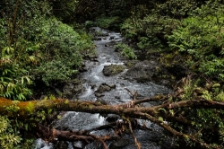
In this activity students will use Google Earth to get a ‘birds-eye’ view of their local watershed. The lesson explores what constitutes a watershed, the many important functions they perform and the need to protect them. Depending on the location and watershed size, students may also consider its international implications. Students will:
- use topographic and street maps to locate their local watershed and the notable natural and built features found within
- familiarize themselves with Google Earth
- use the program to locate their watershed, its boundaries and the features noted earlier on the paper maps
- use Google Earth to ‘fly over’ their watershed and complete the exercise included in the lesson
In addition to watershed facts provided by Google Earth, the resource includes detailed background information for both teacher and student. A number of suggestions for assessment and extending the learning are also provided.
General Assessment
What skills does this resource explicitly teach?
- Using Google Earth
- Reading topographical maps
Recommendation of how and where to use it
This activity will connect any study of watersheds to the student's own community and experience. It would effectively support units in physical geography and science (water systems on earth).
Relevant Curriculum Units
The following tool will allow you to explore the relevant curriculum matches for this resource. To start, select a province listed below.
- Step 1Select a province
- Alberta
- Manitoba
- Newfoundland & Labrador
- Northwest Territories
- Nunavut
- Ontario
- Step 2Select a grade level
- Grade 7
- Step 3Select a subject
- Geography
- Step 4Relevant matches
- Physical Patterns in a Changing World
- Grade 8
- Step 3Select a subject
- Science & Technology
- Step 4Relevant matches
- Earth and Space Systems: Water Systems
- Grade 9
- Step 3Select a subject
- Geography
- Step 4Relevant matches
- Issues in Canadian Geography (Academic): Liveable Communities
- Prince Edward Island
- Quebec
- Step 2Select a grade level
- Grade 8
- Step 3Select a subject
- Science & Technology
- Step 4Relevant matches
- The Earth and Space
- Saskatchewan
Themes Addressed
Water (1)
- Watershed Protection